Archive for category International
Day 1 of the Kalahari Augrabies Extreme Marathon – people dropping from the heat!
Posted by Jacqueline Windh in Africa, events, International, South Africa, ultramarathon on November 9, 2015
{This is my Kalahari ultramarathon report originally published on SleepMonsters. For an overview of what this one-week race is, check out my previous post] “This year will be the real race,” RD Estienne Arndt said to me at the start line. He was referring to last year’s KAEM, when racers didn’t get the full Kalahari Desert experience due to unseasonably cool temperatures and even a few days of rain. In contrast, today’s temperatures were predicted to sit around the mid 40s (well above 100 F), and those conditions are expected to hold for the entire week.

Dave and me at the start line.

And we’re off! Mostly dirt roads, but some cross-country.
It was already very hot as 70 of us set off from the start line at 9am. Starts for the rest of the week will be earlier. Today’s route was by far the easiest route of the week, though – only 25 km, with little elevation gain, rising 100 m over the first half then dropping 200 m over the second half. Those elevation changes may seem trivial to you, but out here in the sun they translate to serious issues of heat management. Even a tiny uphill raises your body temperature, so having the gentle downhill for the later (and hottest) part of the route was a very good thing.

The group is not too spread out yet. Many of us taking it very easy because of the heat.

Approaching our first aid station!
Aid stations were around 8 km apart, so there were two along the route before the finish. Dave and I had been advised to take this day as a training day, and to acclimatize, and we took that seriously. We were well down towards the back of the pack, but we managed ourselves really well. We made the first aid station in around 1:20, so managed to sustain a decent jog/walk pace. Shortly after, we passed a pair of guys from Austria, Josef and Ambros. Josef was obviously in trouble, having knee issues. As we approached the second aid station, Ambros caught up with us jogging, and told us that Josef had dropped out. Shortly after, we passed a 4WD with some of the medical crew, giving a woman an IV.
Less than 10% into this race, and already conditions were taking their toll.

We did run a bit – but mostly we took it very slow.
The route, however, was spectacular – in some places due to the starkness, wide open plains with a few sparsely scattered shrubs. In other areas, traversing rounded granite outcrops, winding our way through dry stream beds (soft sand and no wind, VERY hot but very pretty) and over bare rock hills. We were especially thrilled to see a herd of five giraffe a short distance from the track, less than an hour from the start.
Dave and I kept up our very conservative and relaxed pace. The heat was affecting Dave quite a bit, so we took our time at the second aid station, giving him a chance to cool down. The volunteers here are amazing, many them who have come back many times over the years.
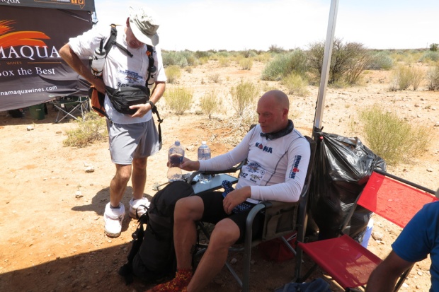
Dave is not looking his best.
It was noon when we left this aid station, and Dave was having a lot of trouble keeping his body temperature down, so we stopped a few times for him to try to cool down. It’s hard to find a good place to stop – the low hilltops had a good breeze but no shade, and the shrubby trees were located only in the dry river beds – stiflingly hot and sandy, and no breeze at all.

Nice scenery – when we remembered to enjoy it!

Dave wasn’t sure he would be able to finish the race at this point…
The last part of the route followed a very hot and narrow dry stream bed, enclosed by rock walls. We rounded a spectacular gap flanked by giant granite boulders, and there was Camp 1 set up – most of the field already here, relaxing in the shade in the gazebos. The temperature here in the shade was 48C, which means out there in the sun and on the hot sun it must have been well into the 50s.

Wejust rounded this boulder – and there was camp! Phew!
That heat definitely took its toll. I don’t have any final results or info, but I heard upon my arrival that 4 racers had pulled out so far. Ambros, in the next gazebo over from me, has been wailing with insufferable cramps, and got carted away by the medical crew for an IV. (Rules here are that you are allowed one IV – if you need a second, you are out).
Edward Chapman of the UK, here for his ninth time, was still well behind us. When he came in, after 6 hours on the course, he expressed concern for his friend Michelle. He had been feeling unwell and had stopped in the shade, so she should be ahead of him – but she had never arrived. Estienne immediately sent out a search crew. As I am writing this, Estienne has just returned to say that they found Michelle unconscious on the track several km out from here, so she also is out.

This is what camp looks like. And what we do here.
He has also informed us that the route will be altered tomorrow because of this heat. The distance will remain the same, but the section between CP2 and CP3 will be changed from “Death Valley” which has no vehicle access, to a more road-accessible route. As Estienne put it, if any other people drop from heat stroke, he needs to be able to get to them quickly by vehicle. I am really glad that they have such excellent safety procedures in place here – it was really clear to all of us today that the heat can kill very quickly, if you end up off track and run out of water.
Prepping for Kalaharai Augrabies Endurance Marathon – our first self-supported staged ultramarathon
Posted by Jacqueline Windh in Africa, events, International, races, South Africa, ultramarathon, wildlife on November 8, 2015
 In October, Dave and I raced the Kalahari Augrabies Extreme Marathon. The race is named for where it takes place: in Augrabies Falls National Park, in the Kalahari Desert, eastern South Africa along the border with Namibia. We’ve both raced multi-day staged ultramarathons before, but this would be our first self-supported race.
 Self-supported means you must carry your own gear – in other words, carry a fairly heavy pack. In addition to the week’s worth of food, we also had to carry all of our clothing for the week (some racers opted for almost no clothing other than what they raced in – yuck!), sleeping bags and mats, and dishes. Race organizers provided hot water (so freeze-dried instant meals were the go) as well as canvas shelters for us to sleep under. Anything else was up to us.
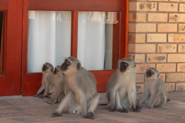
Monkeys showing their stuff. Yup,umm, those are what you think they are…

Cute little monkey family. (I think they are laughing at those boys).

This is the restaurant at Augrabies – frequented by colourful birds and these little dassies.
We were expecting heat – but by the week before the race, the forecast was looking scary! Day-time temperatures for race week forecast to hover around 40°C, or 105°F (and it ended up getting WAY hotter than that). We had been warned about very cold night-time temperatures here, so my husband Dave and I both brought our down jackets. Ha ha,that ended up being a joke.

Compulsory gear check – if we didn’t have all of the required gear, including at least 2000 calories of food per day, we were not allowed to race.
This year’s event had 71 racers entered, 34 of them from South Africa, and the remainder (just over half the field) coming from around the globe: elsewhere in Africa, the Middle East, a great number from Europe, three from Canada (including Dave and me) and one each from Australia and the USA.
Figuring out nutritional needs – packing enough, but not too much, not to mention the right balance of foods – was a challenge. I was carrying enough for close to 3000 calories per day, which ended up being more than I needed. However, I would rather err on that side, than go hungry at the end of a tough week in the Kalahari Desert!

Testing out our sand gaiters – some by ar.co.za and some by Rough Country. They velcro on to the bottoms of the shoes, to keep all sand out (major blister prevention strategy).
Some runners had their packs down to around 7 kg dry weight. Dave’sand mine both came down to 12 kg. We were okay with those weights starting out – not wanting to be missing stuff and suffering out there – but by the end of the race we both had learned so much that we would be able to go way lighter next time. Aid stations were 8-10 km apart, and we were provisioned with 1.5 l of water at each, so we would be carrying up to 1.5 kg of water on top of that dry weight.
Dave and I trained with our weighted packs for only a few weeks before the race. I think I would have been better training with the heavy pack a bit longer than that, as it does put a different type of strain on your joints and your feet – but overall, I was feeling pretty good pre-race.
Planned daily distances were: 25k, 30k, 40k, 80k (overnight stage), 47k, and 21k.

There were monkeys in our camp/race headquarters at Kalahari Augrabies National Park, and nice short walks to view the waterfalls and gorge. Dave and I went out on a two-hour game drive the afternoon before the race (I feel I should be resting – but I cannot resist seeing more of Africa and its wildlife, not to mention get an idea of the terrain we would be passing through). On the drive, we saw eland, springbok and a giraffe!
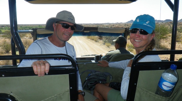
Heading out on our pre-race game drive.

A chance to get a look at the country we would be running through. Not a lot of shade.

Herd of eland.

A springbok.

Our first giraffe!

Another lovely view of the gorge.
Stellenbosch 1 – Tasting wines and olive oils
Posted by Jacqueline Windh in Africa, International, South Africa on October 25, 2015
 This post is labelled #1, because we only had one night booked in Stellenbosch and then were driving east along the coast – but we liked it so much there that we decided to pass through again on our way back. So there will be another post about our wine-tasting adventures around Stellenbosch coming.
 I’m going light on the text and heavy on the photos, because we are still travelling and I don’t want to spend all of my time on the computer. We first visited a winery called Tokara, that also grows olives, so we did an olive oil tasting there. (It was around 10 am… saving ourselves for wines later). Then we moved on to one called BabylonStoring, that also has huge vegetable gardens and orchards, with kilometres of trails. We wandered the gardens there for an hour or two, then had lunch and did a wine-tasting there, before hitting the road – through the wine-producing town of Franzshoek and over the mountains, to our next stop for the night back on the coast.
Tokara Vineyward and Olive Farm:


 Babylonstoring vineyard and gardens


 Hitting the road – from Stellenbosch, over Franzshoek Pass, and to the coast by sunset


Hiking Table Mountain, above Cape Town, South Africa
Posted by Jacqueline Windh in Africa, International on October 23, 2015
 One of the things on Dave’s “definite to-do list” for South Africa was to hike up Table Mountain. Of course I was happy to go along. What a surprise to find out that it rises more than 1000 m above the city of Cape Town!
There is a gondola that goes up to the summit, but of course we would rather walk. We took the Platteklip Gorge route, parking near the bottom of the gondola cable, and hiking from there. We had originally planned to stay in Cape Town only two nights, and to hike Table Mountain either our first or second day, before hitting the road and driving east along the coast.
But the weather wasn’t great for hiking – totally fogged in and windy on the mountain – and we were really enjoying the Cape Town area, and the places we could get to from here (that I’ve already blogged about: the Constantia wineries, and the Cape of Good Hope). And the forecast was looking much better a few days away – so we ended up staying a total of four nights in Cape Town, hiking up Table Mountain on our final day. And, as you will see from these photos, it was worth the wait. It was a stunning day!

Here’s where we parked. We are about to hike up to that pointy peak in the centre, which is where the gondola arrives to.

The start of the Platteklip Gorge Trail – one of the MANY routes up the mountain.

Frogs in the pond at the trailhead. We saw three frogs fighting, biting one another and rolling around. Who would have known?

A pretty steady climb. First view point, looking over Cape Town – only part way up.

Checking out the gorge…

…which the trail follows, to avoid the cliffs.

Partway up the gorge. Views getting ever better! You can see the road below, to get an idea of how far we have come up so far.

Now on top. We were surprised by how many trails there were up here. We decided to take the one to McClear’s Beacon, the highest point on the mountain (which really is very flat on top like a table), before heading back to the gondola for a ride down.

Trail on top to McClear’s Beacon.

Stopped for lunch at the beacon,with great views northward, then followed a different trail back, skirting the cliff edge on the west side, above our car.

Cliff-edge view over downtown Cape Town.

It’s spring here, and there were so many beautiful wildflowers in bloom up here.

Heathers.

(Not sure what these are).

And here’s a view of Lion’s Head, the peak we climbed the other day in the mist and fog – with no views!

Then back to the top of the gondola cable – a much busier place than where we had spent most of our day.

But still with gorgeous views – here looking down above Camp’s Bay. Check out the little rock ledge on the far left – can you see the little furry guy sun-baking there?

Here he is, closer up. He’s an animal called a dassie. Apparently his closest living animal relative is the African elephant. (I would have guessed guinea pig…)

And then the gondola ride down – a very fast trip!

Back to the car around 3pm – now finally leaving Cape Town and heading inland, to the world-famous wine-producing area of Stellenbosch. Blog post about that coming…
Finally! We made it to the Cape of Good Hope, South Africa
Posted by Jacqueline Windh in Africa, International on October 19, 2015
 Well, it took us a long time to get here. The first day, we were waylaid by the wineries at Constantia. Next day, we were delayed by a visit to World of Birds and then to the penguin colonies at Boulders. But, that second day, we kept driving south, and around mid-late afternoon we finally made it to the Cape of Good Hope.
It was 3 or 4 pm, and we hadn’t even had lunch yet. There was a funicular (slanted railway car going up the hill) to the lighthouse above, with a trail alongside. Dave had heard of an award-winning restaurant here called Two Oceans (because this is the place where the Indian and Atlantic Oceans meet – although it is not the southernmost point of Africa) and we thought it might be beside the lighthouse. So we hiked up there – hungry! – and the view was magnificent… but the signs to the restaurant allpointed down, back to where our car was parked.
So we hiked back down, and found the restaurant hidden at the back of the parking lot – but with a magnificent view of False Bay and the shorelines to the north and east (we were on the east side of the cape – the Indian Ocean side). Stopped there for a late lunch of the most tender calamari I have ever tried, and finally around 5pm headed out for our hike to the cape. Here are some pix:

View to the north fromthe lighthouse.

View westward from the lighthouse – that point behind the beach is the Cape of Good Hope.

At the restaurant.

Dave thought it was fun to feed the red-winged starlings from our table at the restaurant. Until he realized that the restaurant provided water spray bottles to shoot them with, to keep them off the dining tables – and suddenly Uncle Dave turned into the starlings’ worst enemy.

Nice view! We saw a fur seal from here, as well as a few mongoose-like mammals. We still don’t have a bird book or animal book, so we are kinda making up the names of the things we see as we go…

Five pm – lunch finally over with, and still an hour or two until sunset, we are finally heading out on a little hike.

A beautiful little beach below – wish we had more time.

View back eastward to the lighthouse. Turned out the lighthouse was too high – ships couldn’t see the light if it was foggy out – so they had to build a new one, lower down. You can just see the new one on the rocks, just above the horizon.

Surprise! We saw ostriches as we hiked to the cape!

View back east towards the lighthouse. The ostriches were on the flat green plateau on the upper left. If you can see any black dots there – that is them!

View from the Cape of Good Hope, downward and to the west. There is another parking lot down there. This now is the Atlantic Ocean (previous pix were the Indian Ocean).

Reptile. Lots of these guys. Since we don’thave a reptile book, I have named him the South African black alligator lizard.

Better ostrich views on the way back. There were small chicks, too – you just can’t see them in my photos. Sorry!

There was a little side-trail on our way out. You are supposed to be out of the park by sunset or you risk getting locked in (and we were still 10k from the gate) – but this would probably be our only time EVER coming here, and we wanted to take advantage of every moment. So we took the side-trail… and we saw our first whales from here! They are southern right whales. There was one right below us, here in the bay, just at the break, and several more further out to sea.

Heading back to our car…hmmm, this road was chockerblock full of cars here when we arrived.

Yup, definitely last car here. And definitely a very full day. We barely made it out of the park, arriving to the gate just as it was closing!
Dave and Val hike the Laugavegurinn trail from Landmannalaugar to Porsmork, Iceland!
Posted by davidjgilbert in Hiking, Iceland, International, lifestyle, snowshoeing, training on August 3, 2015
Valerie and I decided for our yearly summer expedition to hike the wilds of Iceland! We took a special bus with large wheels that could cross rivers from Reykjavik to the central interior area called Landmannalaugar to hike the Laugavegupinn trail.

We are off! Landmannalaugar to Porsmork hike.
Val and I flew Vancouver to Reykjavik, watched the weather while collecting our remaining food and gear, and booked a bus to the start in the central Iceland interior.

Heading up, up and up into the mountains.

Still heading up…

Mountains! I didn’t sign up for this! – Val.
After about four hours there was more snow and ice than rock.

The trail was defined with stakes with red on top, and others had left a trail through the snow.

Dave’s selfie…

Val enjoying the day.

Heading for Alftavatn lake in the distance.
Spectacular views in every direction! Cold winds in the late afternoon.

Val having a hot drink at camp.
Since the sun was up 22 hours in early July, we hiked until 8:30 pm and covered 24 km of high mountain trails. No complaints from Val. We had packed very light so we could move fast and pull long days.

Coming down out of the snow fields.

Windswept volcanic plains.
The mountains gave way to vast volcanic plains, with winds carrying black dust. We moved fast as we didn’t want to be here if any wind storms arose.

Dave selfie with Val in the distance…

Playing crib in our crib…
Cold. We both slept with all clothes on, hat, gloves, and head under the sleeping bag. My MEC down bag to 0 degrees C was not near enough.

Ever changing landscapes.

Getting lower.

A steep bit.
Then on to Porsmork at near sea-level for a bus ride back to Reykjavik for the best hike ever! 55 km, three days.
Sun Mountain 80 km ultramarathon, Winthrop, Washington! Our first 50 miler!
Posted by davidjgilbert in International, lifestyle, races, ultramarathon, Washington on June 2, 2015

Owner Carl at Javaman Burritos
Jackie and I have gone to Winthrop, WA, to run ultramarathons for four years in a row. A stop for burritos at Java Man Espresso and Burrito Bar is now a ritual. Read the rest of this entry »
Ultrarunning around the world – show this Tuesday at Char’s Landing, Port Alberni
Posted by Jacqueline Windh in events, International, ultramarathon on May 23, 2015

Me, on a 5-day race in India. (Ack, the kids are beating me!)
Hey! We know we have readers from around the world – and a big hello to you all. But this is a special post aimed at the locals. If you are one of our local Port Alberni readers, I just want to tell you about the slide show and talk about ultramarathon running that Dave and I will be doing this Tuesday at Char’s Landing. Read the rest of this entry »
A race that is sure to become ultramarathon legend: my Ultrafiord 70 km run, Chilean Patagonia
Posted by Jacqueline Windh in Chile, events, International, races, ultramarathon on May 15, 2015
 About time… here, finally, is my post on the Ultrafiord race I ran last month in Patagonia: at 70 km, my longest ultramarathon to date. I’ve already posted an Ultrafiord race report on RunningUltramarathons.com – but here is a more personal account of what happened.
Well, I have known the Race Director, Stjepan Pavicic, for around 15 years, and I know his style: his motivation is to create races that are big and wild and very very hard. Read the rest of this entry »
Scared: About to “run” (ahem) 70k in wildest Patagonia (Chile)
Posted by Jacqueline Windh in Chile, events, International, races, ultramarathon on April 16, 2015
Wow, this’ll just be a quick note, because I am heading out to the race start very soon: for the inaugural Ultrafiord ultramarathon, here in southern Patagonia, Chile. There are 100 mile, 100k and 70k races going on. I’m running the shortest one… but it’s not that short!! Our time cut-off is 32 hours!!
 I’m in the town of Puerto Natales right now. Here’s a pic from the computer this morning, here at the lovely Hotel Weskar (on the water) at first light, 8:15 am. Our race starts at 8:30 tomorrow morning. So I’ll have 11 or so hours of light, then it’ll be by headlamp after that.
I had originally thought I would do it in 12 hours or so, maybe a bit more. (I did the Angel’s Staircase 60k a year and a half ago in 11:40, and I was injured then). But now that I have seen the route info, I am thinking I could be 16 hours or more. Read the rest of this entry »
