Archive for category Canada
The Golden Ultra Day 2: A 55 km mountain ultramarathon with 2700 m cumulative gain/loss
Posted by Jacqueline Windh in British Columbia, Canada, events, races, ultramarathon on October 5, 2015
I woke up Saturday morning feeling amazing! I had got plenty of sleep – which is rare on multi-day races – and my legs felt great in spite of the previous day’s big uphill. My summer spent climbing mountains around my Vancouver Island home was really paying off. Today I would find out if my downhill training was also sufficient, as the 55 km route was basically one big mountain climb: starting in the town of Golden at 785 m, hitting the summit at 2365 m at our 31k mark, then descending over 1500 m back to town.
A few days previous, the forecast was for rain, but luckily that had mellowed to a total expected precipitation of only 3 mm for the day, with expected temperatures at town-level of around 8C. Of course things can change quickly in the mountains – but that had me make a last-minute decision to not carry my rain jacket after all, and just take a light nylon shell instead. Jacket, hat and gloves were all required gear: all things that I think any of us would have carried on this route anyway, required or not.

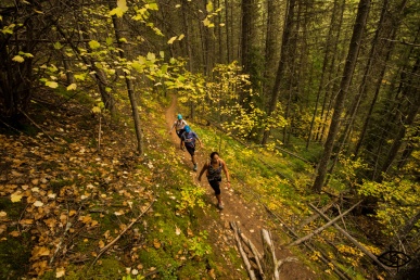
That’s me, with two other local racers, starting out and still in forest. Photo: Bruno Long/GoldenUltra
Three of the three-day racers who had run the previous day chose to DNS, so the field was now down to 48 attempting the full distance. It was just getting light in Spirit Square, downtown Golden, as we headed out: first for 3 or so km down the road alongside the river, then veering left to start the climb through the forest.
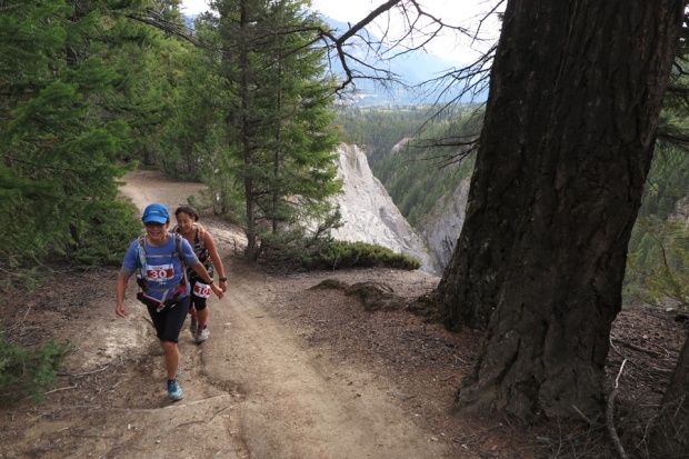
There were a fair few locals in the field, but the rest of us had no idea of what to expect from the route. What a surprise to find that we were rising along the lip of a spectacular canyon! Its irregular lip was on our immediate left – a completely jagged and eroding edge, and from there a 500 m (1500’) dropto the rushing river below. Don’t stumble! Signs warned that this was sensitive mountain goat habitat – I sure wished I had time to hang out here with my binoculars. But the race clock was ticking… I snapped some pix and kept going.
I climbed for a while with a nurse named Jen from Golden- nice to have someone to chat to as we plodded upward. I was faster uphill than her, which gave me the opportunity to get a bit ahead of her and then stop to take pictures (nice when I can actually have people in my photos!) It got colder and windier as we ascended, now along a forested ridgeline, and I soon stopped to rug up, very glad that I had chosen a thick fleece toque for my required-gear hat.
The terrain got rougher and rockier, and by around 1pm Jen and I were in the clouds. You’ve all been there, you know the routine when climbing a new mountain: :this one has got to be the real summit.” Around the third false summit, nearly 2pm, Jen said “We’re gonna be tight to make the aid station cut-off.”
What?? I hadn’t even looked at the cut-off times because I had just assumed I wouldn’t be chasing them! “Yes,” she said, “It’s a 6:30 hour cut-off to Aid Station #2”- which was around the 33 km mark. We were 6:20 into the race, and we could actually see some figures silhouetted in the fog at the next summit (which, hopefully, was the real one). I pushed hard – do NOT want to be DQ’d up here! – trying to balance the need for not generating too much lactic acid in my quads as I ascended with the need not to miss the cut-off.
And we made it! And there was a race volunteer up there with both bad news – the aid station is another 2 km ahead – and good news – it’s an 8-hour cut-off. We still had an hour and a half! (“Oops, sorry!” laughed Jen!). This was at least the actual summit. From here, we followed a very narrow, rocky (and somewhat scary) ridgeline. Jen was much faster than me on that type of terrain. I caught her momentarily when I made the aid station, but then didn’t see her again for the rest of the day.

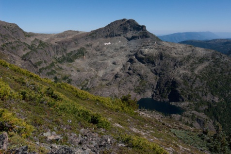
Here’s the view looking back from the 33k aid station – the summit I was on and the ridgeline coming down. LOTS of descending still to go.

Running down (I walked a lot of this stuff, rocks were slippery and wet and it would be a long way to fall!) Photo: William Eaton/Golden Ultra
I was very cold when I hit the aid station – which was the top of the same gondola we had finished at yesterday. My core temperature was actually totally fine, but my hands were cold to the point of barely being able to use them. I needed to eat, but I knew that I could not stand still or I would chill instantly.
Fortunately, there was a little room there, toasty warm, where we could sit to eat! There were two racers already in there recovering from mild hypothermia, and the safety director looked at me, worried, when I entered, asking me all the proper questions to assure that I was OK and not in need of aid. One of the racers was still very cold, unsure if she would continue or not, and the safety director was monitoring her, taking her pulse. The other racer gradually warmed up, and he headed out as I ate.
I spent maybe ten minutes in there, eating as many chips and pretzels and drinking as much water as I could stuff in. The icy wind shocked me when I stepped back out – had I really been running in such cold? But I knew that I would be losing altitude very quickly from here, so I started to run. Down rocks, then eventually down a switchbacking gravel path below the gondola, down down down to the resort we had started at yesterday, then through the parking lot (waved on by race volunteers cheering us on and directing us) and into the forest and down and more down.
Later that night, at dinner, everyone I talked to agreed that this section – between the aid station at 33 km up top, and the next aid station at 44 km, was much longer than 11 km! (I think several km longer). But the terrain was pretty fast – some mud at lower levels, nothing too bad.
And then abruptly I emerged at the same bridge where we had crossed over the Kicking Horse River that morning: just 3 road km and I would be done! I still had pretty good running legs (well, maybe “jogging” is the better word here). A local woman on a bike rode with me and encouraged me the last 500 m, pointing out the finish tent (I thought I was much further out) and motivating me to pick up the pace for the finish – and, to lots of cheering, I made it in.
It was the multi-day racers who killed it today! In all four categories, multi-day racers took top place, finishing ahead of runners who were “only” doing today’s 55k. Notable were the two Open category (under-40) winners.
California’s Jorge Maravilla tore the course to shreds, finishing in an incredible 5:53:37. “It was hard,” he told me. “I’ve never done a race with so much vert.” And the women’s winner, Ailsa MacDonald of St. Albert, AB, put out an equally impressive performance, finishing in 6:18:33 to take second overall! Apparently Ailsa is new to trails, currently making the switch from running road marathons – so I think we will be hearing a lot more about her! Full Day 2 results can be found at https://timing.zone4.ca/results/21166f7b-91f4-8d83-c871-2d7caa6d1559/.
There’s nothing like that feeling when you cross the finish line after a tough race and the tears well up just a bit in your eyes. But no time to dwell on that – I was a good hour longer than I had expected, finishing in 11:25 (cut-off was 12 hours!). Time to get warm clothes on, enjoy dinner with my fellow runners at the adjacent Island restaurant, then get back up the hill to sleep before tomorrow’s final stage
Another big day in the mountains of Strathcona: Castle Crag Mtn., Mt. Frink and Mt. Albert Edward
Posted by Jacqueline Windh in British Columbia, Canada, Hiking, Mt. Washington, Strathcona Provincial Park, Vancouver Island on August 12, 2015

View back from the south flank of Mount Albert Edward – I came around from the left, across the back of Castle Crag (the mountain on the extreme left), then summited Mt. Frink (centre), then took the ridgeline down and to the left of it and back to Albert Ed.
Well, the previous week I’d run/hiked to the top of Mt. Albert Edward and back – a total distance of around 32 km. I had considered adding on the side-loop that would go over Castle Crag Mountain and Mount Frink as well – but after receiving some advice that the navigation was pretty tough on this loop, I decided to bypyass it. That day. But this week, I was back!
Other than this first shot, all the pix were taken on my phone, so they are not that great. And then my phone died before I made my first summit. Stupid thing. Anyway, Read the rest of this entry »
Jackie’s solo hike-run to summit Mt. Albert Edward, Strathcona Provincial Park – 32 km with >1km elevation gain
Posted by Jacqueline Windh in British Columbia, Canada, Hiking, Mt. Washington, photography, Strathcona Provincial Park, Vancouver Island on August 5, 2015
 Wow, now this was fun! It has been a very hot and dry summer – not great for the garden or the salmon, but very good for getting up in the mountains, with little or no snowpack. (Dave and I did that Della Falls/Love Lake run back in June, and there was no snow at all up there – whereas when we did that same Della Falls route in September, late summer, a few years earlier there was not only snow up there, but Love Lake was still totally frozen!) So, while Dave was away in Iceland, I decided to head up to Strathcona Provincial Park (less than a 1.5 hr drive from here) and do a run/jog up to the peak of Mt. Albert Edward. Read the rest of this entry »
I’ve wanted to do this hike for years – Mount Klitsa!
Posted by Jacqueline Windh in British Columbia, Canada, fitness, Hiking, lifestyle, Port Alberni, Tofino, Ucluelet, Vancouver Island on July 29, 2015
 Dave and I had a great mid-July hike with Ron and Brett up Mount Adder. They were planning a trip a couple of days later to Mount Klitsa, and invited us along on that too. I was totally excited about that – I’ve wanted to do Klitsa for years. My old Tofino friend, artist Mark Hobson, had told me about it, but somehow I never had a chance to get up there. Dave couldn’t go this time – he was packing, leaving for Iceland the next day – but I jumped at the chance! Read the rest of this entry »
Run to the top of the China Creek, Port Alberni’s watershed.
Posted by davidjgilbert in Canada, Hiking, Port Alberni, training, ultramarathon on April 23, 2015
Jackie raced her ultra yesterday in Patagonia and I needed a long run and the weather was awesome so I headed up the China Creek Watershed. I parked on the Cameron Mainline at the yellow gate and started up the long hill.
I ventured off the main road to Read the rest of this entry »
Mt. Horne hike with Rich and Xhosa.
Posted by davidjgilbert in British Columbia, Canada, fitness, Hiking, lifestyle, Port Alberni, training on April 15, 2015
Jackie just finished a 132 km hike in Patagonia before her ultramarathon so I’m wandering the mountains here with Rich.
We parked at the yellow gate at the Port Alberni side of Cathederal Grove and walked down the road to the flagged trail start. Read the rest of this entry »
Mt. Wesley Traverse.
Posted by davidjgilbert in British Columbia, Canada, fitness, Hiking, Port Alberni, training, Vancouver Island on April 12, 2015
Jackie is still in Patagonia so Rich, Xhosa and I decided to tackle the Mt. Wesley Traverse. This trail is the ridgeline over the top of the mountains across from Cameron Lake.
Franklin flats to home along the Inlet trail.
Posted by davidjgilbert in Alberni Inlet Trail, British Columbia, Canada, fitness, Hiking, Port Alberni, training, ultramarathon on April 10, 2015
Since Jackie is in Patagonia getting ready to run a 70 KM Ultra, I ran from Franklin Flats along the Inlet trail to Read the rest of this entry »
Made it through the Comox Valley Half-Marathon last weekend!
Posted by Jacqueline Windh in British Columbia, Canada, events, races, Vancouver Island on March 25, 2015
 Well, some day I will actually run a decent half-marathon. My best marathon time is 3:56, so you’d think I’d be able to run a half in 1:55 or less. But something always seems to go wrong for me – injury or illness. Well, this time, running the Comox Valley Half-Marathon, the problem was respiratory stuff: a cold I came down with over five weeks ago, which turned into bronchitis.
So of course that affected my training – although I did manage to continue training at some level through it all (experimenting with HIIT, high-intensity interval training, which meant very short but high-intensity workouts on the exercise bike rather than doing much running). I also could do weights.
So basically I entered the race with my legs feeling great and strong, but my cardio fairly poor, and my lungs still not healed. I went there with my friend Gail – we got a hotel and had a nice Thai dinner the night before, and were very appreciative of the generous 11am race start time. So at least we were having fun!
Gail was hoping to run under 2 hours, and I honestly didn’t have any idea of what time I would take. I told Gail I could be anywhere between 2 hours and 2:15 – possibly even more. The whole route is an out-and-back: a gentle uphill out and downhill back. I figured I would go as fast as I could conservatively sustain going out – and if I was still up to running, I would aim for a negative split coming back.
Highlights on the way out were seeing a bunch of crazy people on the side of the road, wearing weird wigs and blowing kazoos – and realizing that they were Ryan and Andrea! (They used to live here in Port Alberni). And also the huge dead tree on the side of the road with an eagles’ nest and the two eagles watching over us.
I made it to the turnaround in 1:01.45. I realized it would be tight to make 2 hours, but it wasn’t impossible – I’d have to make up 3 and a half minutes on the way back – so I went for it.
I calculated my time at every kilometre marker, and was running around a 5:30 kilometre. But I needed to do around 5:20 to make my 2 hours. Would I have enough left in me to sprint in the final 2 km?
By the 19k mark, I realized I wasn’t going to make it. I let off the pace, and finished in around 2:01:20 (my official race time was 2:01:39 – they’re not showing the chip times for some reason, though). Oh well, it still is a half-marathon Personal Best for me (as pathetic as that is! leaving me lots of room for improvement). And I did achieve a pretty good negative split – under an hour on the return. (Gail achieved her goal too, finishing in 1:58!).
Honestly, I am pretty happy with running that time considering the health problems I have had. Some day I will run faster… Big thanks to Ryan and Andrea for hanging out on the course for my return, so Ryan could get this great photo of me (smiling even)!
Alberni Valley Outdoor Club – volunteer trail-builders!
Posted by Jacqueline Windh in Alberni Inlet Trail, British Columbia, Canada, Hiking, Port Alberni, Vancouver Island on March 12, 2015

Alberni Valley Outdoor Club work party on Roger’s Creek trails (Ivan, Harold, Randy,Dave, Steve and Mike – and Xhosa acting like she was helping)
Hey, just a quick post here…. I was out for a run with Xhosa a few weeks ago on the Roger’s Creek Trails. Somehow we haven’t blogged about these trails much here, but this is a fantastic trail system right in the heart of Port Alberni, and Dave and I are on these trails all the time – at least several times a week. I’d noticed over the previous week or two that someone had been working on the trail: improving drainage around the wet spots, fixing up stairways, etc. Read the rest of this entry »


